By Scott Sullivan
Editor
Rumors of the Blue Star Trail’s death may be premature, witness backers’ response to a temporary state grant turndown and perhaps a July 21 Commercial Record front-page headline “$1.72+ million Trail request dead ends, for now.”
Assuming one overlooks “for now.” Defeat and delay are different.
Project engineer C2AE’s response to a July 8 letter from Michigan Department of Transportation official Julie Thomas’s explaining why the Tri-Community Trail Committee’s $1.725-million ask had been nixed explains how concerns raised will be addressed. That response was confirmed after last week’s deadline, before the CR could secure it for better context.
For 12 years the 501c3 nonprofit Friends of the Blue Star Trail have raised funds to build a nonmotorized recreation path linking current trails leading into South Haven 20 miles north to Laketown Township’s 16-year-built Beeline Trail, which in turn connects further north through Holland to Grand Haven.
For years there’s been nationwide support for extending such trail networks based on local commercial benefits and fighting widespread obesity. The nonprofit has raised its own funds, plus obtained grants and easements to build stretches here.
Douglas and Saugatuck Township have completed segments of the Blue Star Trail’s northern 4-mile section through the tri-communities, but past Saugatuck city leaders balked, citing safety concerns crossing the Blue Star Bridge north from Douglas and Lake Street in particular. The status of the palette sign there and legacy post-construction maintenance costs were concerns as well.
With departures of 14-year city manager Kirk Harrier and several veteran council members, that stance changed. Saugatuck city joined Douglas and the township in a joint committee led by new Saugatuck City Council member Holly Leo seeking to complete the Trail through this region.
The city in fact was lead agent seeking the state-administered (via federal dollars) Transportation Alternatives Program (TAP) grant for an estimated 70 percent of the estimated $2.21-million local trail construction work. Saugatuck city and township are seeking additional Michigan Natural Resources Trust Fund grants of $300,000 each.
Backers were thrown for a bit of a loop on receiving MDOT’s July 8 response (reprinted here last week in full) calling for, in particular:
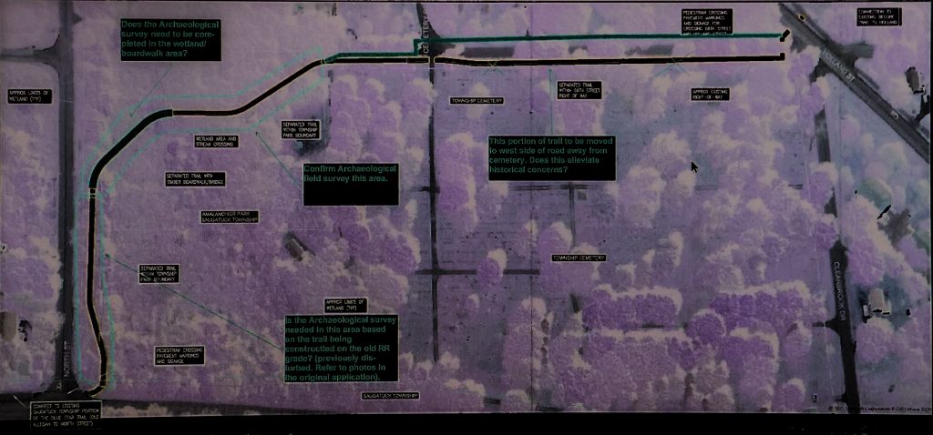
• Relocating a township stretch east from Holland Street to connect to an already-built north-south section west of Blue Star, due to State Historic Preservation Office (SHPO) concerns about disturbing possible Riverside Cemetery grave sites;
• Disturbing Saugatuck city’s iconic palette sign northwest of the Blue Star-Lake Street corner; and
• To meet American Association of State Highway and Transportation Officials (AASHTO) concerns, Blue Star Bridge deck plans may need to be modified.
For the local committee to meet alphabet-soup-of-agency (figure the fed in here too) concerns, advised Thomas, archeological surveys and cultural resources consulting studies should be completed before supplementing its grant application, most likely in fiscal year 2025.
Trail backers at a July 20 special Saugatuck City Council meeting criticized that Commercial Record headline and story, which was online but had not yet appeared in print, for “jumping the gun” and “lacking context” on a 13-day-old public document before a response — taking all concerns, moving parts and doing “due diligence” — could be mustered.
News isn’t news when it’s old, city planning commission chair and Trail plan critic Dan Fox responded at that session.
“Suggested revisions are a normal part of the complicated process,” said Friends secretary Richard Donovan. “We are moving ahead and planning the next section.”
The CR received C2AE’s official response July 22. It is quoted here, shown with a revised project map, verbatim.
“Township has given approval to move the proposed trail location to the west side of 66th Street to avoid any potential conflicts with the cemetery. Refer to the attached marked up drawing. Please indicate if this alleviates all the above concerns regarding the cemetery …
“The City is willing to hire a qualified archaeologist to conduct a field survey (Cardno) per your request. They are in the process of soliciting a proposal for this work. There are a couple of questions with regards to the specifics of your request to be sure that the archaeological survey will be completed within your expectations. Please refer to that attached marked up plan sheet of the area to assist with answering the following questions:
“For the trail section that parallels North Street from the Blue Star Highway to the west, the trail will be constructed on the old railroad roadbed. There is also a fiber optic cable that was constructed under this railroad bed. Since this area has previously been disturbed by construction is the archaeological survey needed in this section? You can see the previous grade mounding and construction work in the project photographs submitted with the original TAP application.
“It is mentioned above that the survey should be conducted north and south of the creek terrace. What is meant by the term creek terrace? Does that include the wetland areas adjacent to the creek or really just the upland areas where the trail goes through the undeveloped area? Refer to the attached drawing.
“If you could mark on the attached map the specific areas you would like the archaeological survey completed that would be of great assistance. We may want to have Cardno coordinate directly with you on this, so contact information would be appreciated.
“We have reviewed the site and previous bridge plans to see where this portion of the project would not be compliant with AASHTO or MDOT standards. We have confirmed that both the cross slope and longitudinal slopes are compliant, and have previously demonstrated in the January response that the cycle track/roadway configurations are compliant.
“The only thing that we see that may need some work is that minor repairs to a couple areas of the bridge surface (within the cycle track only) may be needed. The bridge deck had an epoxy concrete resurfacing about 10 years ago and there are minor areas of spalling (breakage into fragments).
“If there are other, specific detailed comments/concerns that you have regarding AASHTO/M DOT compliance, please provide them, because we are not seeing anything else.
“Per the above discussion, costs for addressing some minor bridge deck surface repairs can be included in an updated cost estimate …
“The comment to include costs to update the bridge rails appears unwarranted by the construction of a cycle track within the bridge deck.
“The 2012 AASHTO Guide for the Development of Bicycle Facilities specifically states on page 4·42 that ‘In locations where bicyclists will operate in close proximity to bridge railings, then a minimum height of 42 inches’ is needed.
“However, there are no proposed improvements to the existing pedestrian walkways, and the cyclists will not be in close proximity to the bridge railings. They will be a minimum of 8 feet from the bridge railing on the west side, and also separated by a 6-inch curb. The bridge rail on the east side would be across 3 lanes of traffic, a 6-inc curb and 5-foot sidewalk away from any cyclists.
“The (MDOT) comment is also very generic as to what current design standards would be applicable. We have just mentioned above that they should not need to meet a bicycle rail height of 42 inches because they are not in close proximity. We have roughly estimated that to remove and replace both bridge railings would cost in the neighborhood of $600,000 (depending on which standard is to be met), which would likely kill the entire project, unless MDOT is willing to fund this extra work.
“In light of these questions, could you please be more specific on the following:
“Under what authority/standard does the placement of the cycle track on the bridge deck dictate that bridge rail upgrades are required?
“If they are required, what specific design standards are you referencing?
“This may have been discussed before, but the City would be willing to remove the portion of the cycle track on the bridge deck and approaches from the project application and construct them with local funds prior to the trail construction if that makes it easier on MDOT to approve this project.
“The City is also getting a proposal from Cardno to conduct a cultural resources review in addition to the archaeological work. Unless it is cost exorbitant the City plans to engage their services …
“Based on information provided by the City, that particular (palette) sign (at Blue Star and Lake Street) was relocated to that position/location around the year 2000. So all of the site work, foundations, lighting, landscaping and road/curb modifications were completed about the year 2000.
“So certainly none of the site location, construction or site context is historic with regard to that sign. Additionally, the City has indicated that that is not an original sign but one of several copies made from the original. The City is currently looking for additional documentation to provide. This can also be further documented in the cultural resources review …
“As stated previously it is now intended to construct the trail on the west side of 66th Street to avoid any potential conflicts with the cemetery. During the cultural resources review, the eligibility for listing of the cemetery and sign can be investigated, but based on the above information, the sign is very unlikely. And since the trail is being moved to the west side of 66th Street, is the cemetery still of concern?
“We would prefer to continue to plan on utilizing the proposed schedule in the grant application until the above issues can be further resolved. Once the above questions are answered we can mutually make a better determination on the schedule.
“Thank you for your time Julie in reviewing these items with us over the phone. Based on our discussion it was determined that the above line of questioning would be the most applicable response that we can make at this time,” the Trail engineers’ response said.