By Gari Voss
The new district boundaries were approved by the Michigan Independent Citizens Redistricting Commission (MICRC) on December 28, 2021 in an 8 to 5 vote. This was the first time Michigan utilized an independent redistricting commission since the 2018 vote that transferred the power to draw congressional and legislative districts away from the state legislature.
In the 2018 election, voters approved Proposal 2, a constitutional amendment that established a redistricting commission. This commission, comprised of four democrats, four republicans, and five unaffiliated voters, was charged with the task of not only redistricting but of making the process transparent to Michigan voters.
The process was hindered by a late release of Census 2020 data, but once it became apparent that Michigan would lose a congressional seat, going from 14 to 13 seats, the commission began soliciting mapping suggestions and holding Town Meetings around the state. These meetings were in person and livestreamed for anyone interested.
From the information gleaned and the Census numbers, the commission designed a variety of redistricting configurations. Drafted maps were presented at Town Meetings and adjusted utilizing suggestions. The guidelines included: 1. Demonstrating “equal population as mandated by the U.S. constitution” and “complying with the voting rights act and other federal laws”; 2. Creating “geographically contiguous” districts; 3. Not providing “a disproportionate advantage to any political party”; 4. Not favoring or disfavoring “an incumbent elected official or a candidate”; 5. Demonstrating “reflection consideration of county, city and township boundaries”; and 6. Ensuring that districts are “reasonably compact”.
Keeping the counties intact and minimizing the number of city and township boundaries split between districts was a guideline but not a requirement. But this became a concern because the newly drawn maps split a number of counties between districts.
As important as preserving boundaries was a desire to consider “communities of interest”. Those are areas united by shared public policy concerns. The constitution states that communities of interest “may include, but are not limited to, populations that share cultural or historical characteristics or economic interests.”
During Town Hall meetings, a variety of communities of interest groups voiced concerns as the commissioners began drawing lines. These included people from similar ethnic backgrounds, religious affiliations, and groups like vacation property homeowners along the lakeshore. Commissioners listened intently because historically Michigan has valued community interest groups, and these groups were submitting possible maps for the commission to consider.
Added to the list of what to prevent was political gerrymandering. Previously, the redistricting commissions had been accused of drafting maps that gave more advantage to Republicans. The 2011 commission was touted as creating some of the most gerrymandered congregational districts in the country. This was based on the fact that the state voted for a Democratic president, but the State legislature was loaded with Republicans.
The transparent process was slow and grueling at times, but the commission conducted their last series of Town Hall meetings and weighed the last recommendations in December 2021. This led to the final vote on December 28 th . Two Democrats, two Republicans, and four nonpartisan members were in favor of one plan while the five remaining commissioners favored other plans. The results met the requirement that at least two commissioners affiliated with each major party and at least two commissioners affiliated with neither major party assented to the plan.
The Vote of 8 to 5 demonstrated that commission members were still not in complete agreement, and communities of interest had their misgivings. These concerns were voiced by Politico who shared, “[the decision] will create battleground districts centered around the cities of Grand Rapids, Lansing and Flint. In a good year for the GOP, they could control as many as nine of the 13 districts. In an unfavorable environment for Republicans, that number could drop to four. Overall, the map creates seven districts that voted for now-President Joe Biden in 2020, and six that then-President Donald Trump carried last year.”
Within days of the vote, a lawsuit was filed against the redistricting commission that alleged the approved congressional and state legislative districts would diminish the political power of Black political leaders in Detroit. The five plaintiffs believed this was in violation of the federal Voting Rights Act, and would reduce minority voters’ opportunity to elect their preferred candidates.
Bruce Adelson, the voting rights attorney for the commission, explained that the law does not require that the commission create majority-minority districts that favors voters of white or color. Adelson believed that with the voters of color spread across more districts, they would have additional opportunities to influence the voters in more districts.
At the same time, Michigan’s Republicans are weighing their options and considering their next moves in contesting the new maps.
Included in consideration was where current legislators lived, but this did not prevent the final configuration from affecting a variety of sitting legislators. Unlike allegations from the past, the new map does not appear to favor any incumbent or major political party.
West Michigan is looking at Republican incumbents Fred Upton (previous 6 th District) and Bill Huizenga (previous 2 nd District) vying for the new 4 th District. (At this time, Upton has not decided to run.) Peter Meyer, a more moderate Republican, will vie for a position in the extremely Republican areas in Kent County and a Democratic area of Kentwood.
Incumbents on the East side of the state are already adjusting. Even though members of Congress are not required to live in the district they represent, U.S. Representative Debbie Dingell (D) plans to move to Ann Arbor so she does not have to run against Rep. Brenda Lawrence (D) while Rashida Tlaib (D) plans to run in the new congressional district encompassing Dearborn, Southfield and a section of Detroit. Representatives Andy Levin (D) and Haley Stevens (D) are slated to run for the same district.
While changes will be brought about by the new maps, political experts outside Michigan are impressed with the work of the new commission. Nick Corasaniti of the New York Times explained how the Republican gerrymandering of 2010 has been neutralized. This means, the new maps for Congress, the State House and State Senate have restored “a degree of fairness.”
The composition of the districts gives a “slight Republican advantage” because Democrats tend to be concentrated in densely populated areas. This is true with people of color. But because of that density, Detroit’s State Senate delegation will increase from five to nine members and the State House delegation will increase from nine to 15.
Though the State Senate creates about 20 seats that would have been carried by President
Biden in 2020 and 18 districts would align with the former President Trump, there is no
guarantee that either party has an advantage in coming elections.
In the midst of the changes and questions, there are 20 competitive districts that provide opportunities for candidates of all parties. “With lawmakers excluded from the mapmaking process, Michigan’s new districts will more closely reflect the overall partisan makeup of the hotly contested battleground state,” Corasaniti stated.
What began as a Facebook post by Katie Fahey after the 2016 election has grown to fruition. Where other states that utilize independent redistricting commissions have struggled and have required external support, Michigan has achieved their goal.
“This is about voters taking our power back,” said Nancy Wang, the executive director of Voters Not Politicians. “All we wanted to do was get to where we are now.”
The maps will become law 60 days after the MICRC publishes a report on the redistricting plans with the secretary of state. Some are waiting for the final decisions of the court that could require the commission going back to the drawing board.
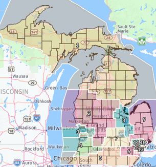
Redistricting 2021 includes 13 federal congressional districts. This was the first Michigan redistricting completed by an independent commission as required by voter approval of Proposal 2 in 2018.
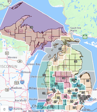
Michigan’s new State Senate districts favor Republicans, but a more balanced at 22 to 15 Republican than previous district maps. (The “Linden” map)
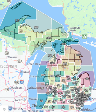
Michigan’s new State House districts slightly favors Republicans based on partisan fairness measures and reduces the number of districts that contain Black voting-age residents because of tying Black areas with suburban communities. (The “Hickory” map)