By John Brice
Corresponden
In the aftermath of the severe thunderstorm in the early hours of Sunday March 26th, 2023 that caused flooding in Chambers County as well as Troup County and the subsequent tornado that resulted in extensive damage to northern West Point, there was much anxiety amongst Chambers County residents in the early morning hours of Monday, March 27th.
Rotation was observed in a storm system that moved over LaFayette and headed east towards Lanett which caused the following alert to be broadcast by the National Weather Service Office in Birmingham “Tornado Warning for…Central Chambers County in east central Alabama…Until 545 AM CDT. At 503 AM CDT, a severe thunderstorm capable of producing a tornado was located near Buffalo, or near Lafayette, moving east at 30 mph.
HAZARD…Tornado. SOURCE…Radar indicated rotation. IMPACT…Flying debris will be dangerous to those caught without shelter. Mobile homes will be damaged or destroyed. Damage to roofs, windows, and vehicles will occur. Tree damage is likely. * Locations impacted include…Lanett, Lafayette, La Fayette, Lakeview, Amity Park, Fredonia, Veasey Creek Park, Denson, Buffalo, Rocky Point, Southern Harbor and White Plains. PRECAUTIONARY/PREPAREDNESS ACTIONS…TAKE COVER NOW! Move to a basement or an interior room on the lowest floor of a sturdy building. Avoid windows. If you are outdoors, in a mobile home, or in a vehicle, move to the closest substantial shelter and protect yourself from flying debris.”
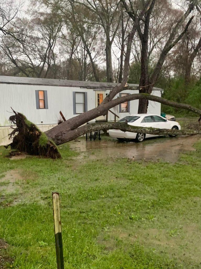
No evidence has been gathered as of yet to conclude that a tornado touched down at any point in Chambers County on Monday morning which was a cause for relief when the tornado warning was canceled by the NWS-Birmingham despite the heavy rain that exacerbated flooding and already saturated ground from the previous day’s severe thunderstorm.
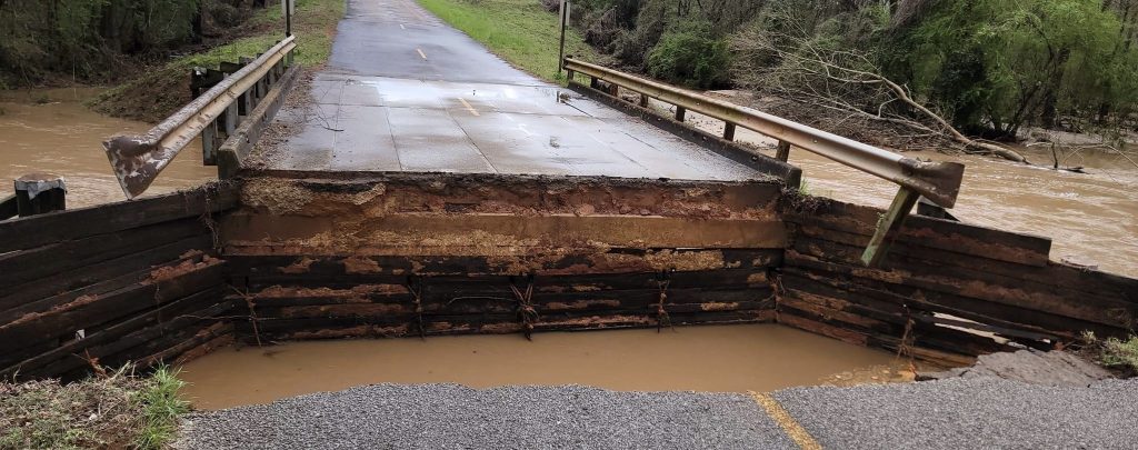
As the sun rose, flooded roadways, downed trees and collapsed asphalt that had sunk into the wet ground became disturbingly apparent. Shocking destruction to heavily traveled roads in the area prompted the Chambers County Emergency Management Agency to issue the following announcement “IMPASSABLE TRAVEL ADVISORY: Effective 8 am central time, March 27th 2023, all roads and bridges in Chambers County should be considered IMPASSABLE until further notice. Members of the general public are advised that when roads and bridges become IMPASSABLE all travel should be suspended or delayed. Only emergency vehicles should travel on county roads and bridges until further notice.”
Chambers County Highway Department Engineer Josh Harvill issued an update at 8:07pm Monday evening via the official facebook page for the C.C. E.M.A. stating “RESUMPTION OF TRAVEL: Effective 6:15 pm central time, March 27th 2023, conditions have improved and the previous IMPASSABLE TRAVEL ADVISORY for Chambers County roads and bridges has been lifted. Because county officials cannot guarantee the conditions everywhere, drivers are reminded to use caution while traveling.
The following roads remain closed: County Road 09 is closed 0.66 miles Northwest of Highway 50 at Hunter Creek, County Road 09 is closed 0.76 miles Northwest of County Road 33 at a tributary to Chatahospee Creek, County Road 32 is closed 2 miles West of County Road 28 at a tributary to Chatahospee Creek, County Road 32 is closed 0.8 miles East of County Road 28 at a tributary to Finley Creek, County Road 48 is closed 0.43 miles West of County Road 54 at the Bridge over County Line Creek, County Road 48 is closed 2 miles West of County Road 98 at the LaFayette City Lake Emergency Spillway, County Road 98 is closed 2.17 miles Northwest of County Road 48 at the Bridge over Chatahospee Creek, County Road 161 is closed 0.34 miles East of County Road 158 at the Bridge over Carlisle Creek, County Road 246 is closed 0.47 miles North of County Road 253 at Davis Creek, County Road 92 is closed 2 miles North of County Road 87 at Oseligee Creek, County Road 66 is closed from CR 51 East to County Road 28, County Road 65 is closed from CR 66 East 3.5 Miles to the Bridge over a Tributary to Chatahospee Creek.”
Elevated water levels could be observed from the banks of the Chattahoochee River adjacent to downtown West Point and in nearby creeks in Lanett, however, those bodies of water have not overflowed as of Monday afternoon despite the two days of heavy rainfall. Flooding was especially bad on North Gilmer Avenue/Highway 29 in Lanett beginning midway between Cherry Drive and North 7th Street in front of Greene Super Drug and extending for several blocks west. Road traffic was blocked at the corner of West 7th Street and Highway 29 in downtown West Point due to the flooding in Lanett despite the immediate area on the Georgia side of the state line remaining relatively unharmed.